This Page offers links to Alaska information and
other State of Alaska Information complements of the Alaska RiverSide House
Alaska RiverSide House Alaska River View Lodge
Double Rooms Suites Restaurant Lounge Lobby Location Map
Fish Facts Vacations Info Request Alaska Info Policy

Soldotna
Chamber Home Page
Information,
links and images about the "Northern Lights"
Alaska State Ferry System Home page
University of Alaska home page
Kenai
Community Information
Fairbanks Convention. & Visitors Bureau
Anchorage Chamber site
Juneau Convention. & Visitors
Bureau
Haines Visitors Bureau
Skagway Convention. and Visitors Bureau.
Seldovia Chamber of Commerce
Kenai Peninsula road mileage
chart
Soldotna to Kenai...................... 11 miles
Soldotna to Sterling....................14 miles
Soldotna to Copper Landing......47 miles
Soldotna to Seward.....................96 miles
Soldotna to Kasilof.....................14 miles
Soldotna to Clam Gulch.............23 miles
Soldotna to Ninilchik..................40 miles
Soldotna to Anchor Point...........61 miles
Soldotna to Homer.....................77 miles
Soldotna to Anchorage.............149 miles
RVN4FUN - Adventure Vacations
ALASKA STATE SYMBOLS
TREE: Sitka Spruce
FISH: King Salmon
GEM: Jade
MINERAL: Gold
SPORT: Dog Mushing
BIRD: Ptarmigan
FLOWER: Forget-me-not
MOTTO: North to the Future
SONG: The Alaska Flag Song
NICKNAME: The Great Land
CAPITAL: Juneau
HIGHEST POINT: Mt.McKinley, 20,320ft.

STATE FLAG
Eight stars of gold on a field of blue, representing the Big Dipper
and the North Star.
ADMITTED TO THE UNION
January 3, 1959 as the 49th State
STATE POPULATION
570,000 (July 1991)
COASTLINE
47,300 miles
LAND AREA
586,412 square miles or about 365,000,000 acres. Alaska is the
largest state in the union, about 1/5th the size of the entire Continental United States
and more than twice the size of Texas.
WATER AREA
3 million lakes, more than 3,000 rivers
LARGEST CITY - POPULATION
Anchorage, population 250,000 (1995)
LARGEST CITY - AREA
Juneau with 3,108 square miles (largest city in square miles in
North America).
OLDEST BUILDING
Erskine House in Kodiak, built by the Russians between 1793 and 1796
EMPLOYMENT
Oil/Gas, Fishing, Tourism and Government are the largest employers
in the State.
CROSSING THE BORDER
No passport needed - Canada requires proof of automobile insurance.
GOVERNOR
Tony Knowles
FISHING AND HUNTING LICENSES
Sportfishing fees for non-residents are $10 for a 1-day permit, $15
for a 3-day permit, $30 for a 14-day license and $50 for an annual license. Non-resident
hunting license is $85; however, there are additional charges for big game tags. A
combination sportfishing and hunting license is $135 annually. For more information,
contact: Alaska Department of Fish and Game, Division of Licensing: PO Box 3-2000; Juneau,
Alaska 99802-2000; (907) 465-2376.
LARGEST STATE PARK IN THE NATION
Wood-Tikchik State Park with 2.5 million acres of wilderness -
located in the Bristol Bay area.
WORLD'S LARGEST CONCENTRATION OF BALD EAGLES
Along Chilkat River, just north of Haines. Nearly 4,000 bald eagles
gather here in fall and winter months for late salmon runs.
LARGEST FRESH WATER LAKE
Iliamna - 1,150 square miles
HIGHEST/LOWEST TEMPERATURES
Highest: 100 degrees F at Fort Yukon, 1915;
Lowest: -80 degrees F at Prospect Creek Camp, 1971
TYPICAL ALASKAN
According to 1990 census figures, 28.9 years old and male - this
compares to 32.3 years for the United States. About 52 percent of Alaskans are male, the
highest percentage of any state.
PER CAPITA PERSONAL INCOME
$23,788 in 1990, 8th highest in the nation.
MEDIAN HOUSEHOLD INCOME
$41,408 in 1989 (latest available), second highest in the nation.
LIQUOR LAWS
Alaska's drinking age is 21. It is required that a person have an
I.D. on there person to be in the establishment Alcohol is available in liquor stores and
bars in many towns. Some villages are "dry" and it is against the law to
transport liquor into them, even for personal consumption.
TIME ZONE
Almost all of Alaska is in the Alaska Time Zone, which is one hour
earlier than Pacific Time. The western most Aleutian islands and St. Lawrence island are
on Hawaii-Aleutian Time, two hours earlier than Pacific Time.
SPEED LIMITS
The speed limit on Canadian portions of the Alaska Highway is 50
miles per hour, and on non-urban Alaska highways, 55 miles per hour. The state has stiff
fines and penalties for littering or driving while intoxicated.
HOLIDAYS
In addition to all U.S. holidays, Alaska observes Seward's Day, the
last Monday in March, which commemorates the signing of the treaty by which the United
States purchased Alaska from Russia in 1867; and Alaska Day, October 18th, the anniversary
of the formal transfer of Alaska from Russia.
FOREIGN CURRENCY EXCHANGE LOCATION INFORMATION
Banks and money exchanges throughout Canada and Alaska will exchange
foreign currencies. Some will charge for the service. Major bank cards and credit cards
are widely accepted.
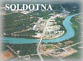
The History of Soldotna Alaska
Soldotna is on the Kenai Peninsula, 150 highway miles south of
Anchorage, at the junction of the Sterling and Kenai Spur Highways. It lies
10 miles inland from Cook Inlet, and borders the Kenai River. It lies at
approximately 60° 29' N Latitude, 151° 03' W Longitude (Sec. 32,
T005N, R010W, Seward Meridian). The community is located in the
Kenai Recording District. The area encompasses 7 sq. miles of land and 1
sq. miles of water.
The Peninsula has historically been the home to Kenaitze Indians, and was
developed by non-Natives for its rich resources, including fish, timber and
oil. Soldotna was named for a nearby stream; it is a Russian word meaning
"soldier." Others believe it is derived from an Indian word meaning "stream
fork." The first homesteaders were World War II veterans, given a 90-day
preference over non-veterans in selecting and filing for property in 1947.
That same year, the Sterling Highway right-of-way was constructed from
Cooper Landing to Kenai. Soldotna was the site for the bridge crossing
the Kenai River. A post office opened in 1949, with stores and a
community center shortly thereafter. Soldotna continued to develop
because of its strategic location at the Sterling-Kenai Spur Highway
junction. In 1957, oil was discovered in the Swanson River region, bringing
new growth and development. Soldotna was incorporated as a city in
1960.
hotel Main Page
hotel single room pictures and info
hotel double room pictures and info
hotel suite pictures and info
restaurant pictures and info
lounge pictures and info
hotel lobby picture
hotel map and picture
hotel and RV policy and info
hotel vacation fishing package
Alaska facts and information links
Alaska fish facts, pictures and dates
hotel information inquiry form page
Last updated 07/24/2001