| Family | Friends | Opinions |
| Web Log | Blog 2005 | Blog 2006 |
| Interests | Health/Fitness | Links |
| Tech Stuff | Crazy Ideas | Theories and Observations |
I'm too smart for my own good. I think about better ways to do all kinds of things. I just wish people would listen! I get tired of talking about this stuff, so I'm blogging from now on.
"Anyone who has never made a mistake has never tried anything new."
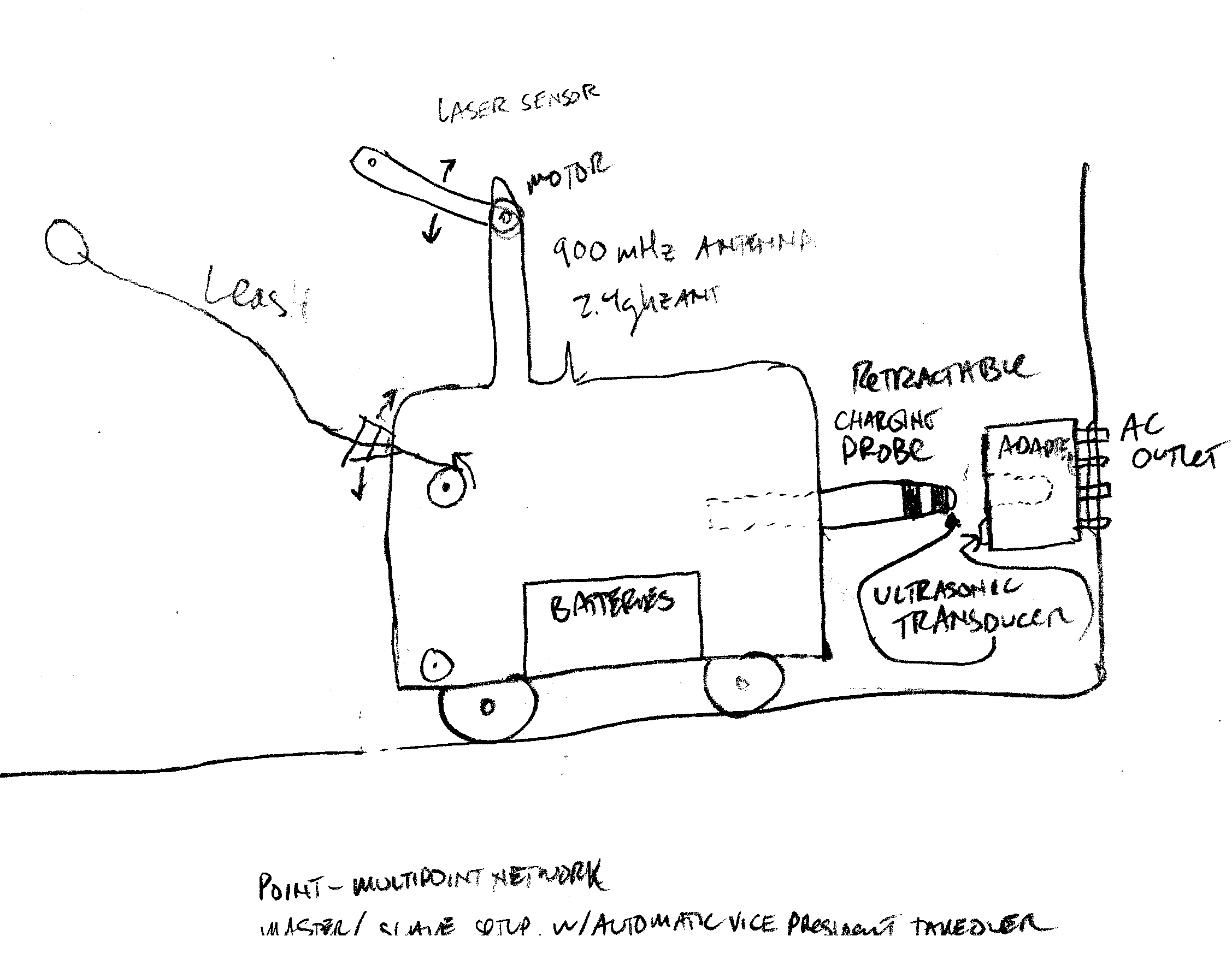
Like Hello! Why don't robots charge themselves? Roomba does, and the lawnmower also does. This is the first thing that a robot should be able to do- Feed itself! Power is everywhere, so why would a human have to plug it in or change the batteries. Here is a sketch of one way to solve this problem.
Active camoflage- use a digital camera and a flat panel display placed on the opposite side of a vehicle. If you know which direction your attacker is, you can am the camera in the opposite direction so they see the terrain they would see if you were not there. I later read about this in NASA Tech Briefs. One devious application is to put a large flat panel display on the rear of your car and display an image of the road in front of you. This would not be too smart as you would soon be rear-ended. Here is a rebuttal on why this won't work so well.
2. Credit to David Hall- use gears to reverse the direction of rowing so that you can face forward. 3. A menu system that had areas on the screen that you could use a joystick and a button to select various programs. (8th grade, 1979 or so) There are many more and I will post them as I think of them.
Here are some more items to add to image files:
First, a frame of reference: 1= earth coordinates 2=Sun coordinates 3=Galaxy Coordinates. You astrophysicists can help me out here.
Latitude/Longitude/Elevation
Direction Vector (which direction was the photo taken). This would be 2 angles, azimuth, and elevation.
Aperture Setting (Useful for scaling bitmaps in 3-D Software)
A 3-D application could use this information to generate realistic 3-d model of the earth. Set up a distributed database of photo files so that you could share/search for photos of a particular location.
This could connected with a flight simulator program that would load images of terrain as you flew over it. The limiting factor would be the speed of your internet connection.
Make a master file server that would link to peoples FTP photo servers. This master server would have a model/map of the globe. You could zoom in and when you got to the area of interest, all these v-shaped objects would be superimposed on a topo map of the area. Each would represent a photo. The lat/long is obvious, the azimuth is given by the direction the v is pointing and the angle of the v indicates the aperture. A fish-eye would be a flat line, so you would have to make a special v with a camera on one side.
This creates a need for a special photo editor that would allow you to import all your photos and add the lat/long/alt/az/el/ap tags to it. It would have a user-friendly graphical interface with a map of the world. It would remember spots you went to often in your favorites.
Make installation wizards a little more like a wizard instead of a dumb butler. Pre configure all the questions/options so you can do a batch install (remember those?). Have a master application installation utility tha twill install everything in one shot. Include connect to the ftp site of each application to get the latest version, or a version of your choosing. This master application could also store all of your authorization codes/keys etc.
Windows Update is notorious for leaving behind junk files. Disk cleanup doesn't deal with these and they clog up your hard drive, slowing down your computer.
Add USB and/or ethernet ports to everything. Like a car, add an interface for a usb stick, or an ethernet cable, so you can download mileages to an app on your computer such as turbotax. There is so much more to this idea.
Add a gps unit to a camera to stamp lat/lon/altitude info on the photo. All cameras now have clocks built in, so why not a gps? Add an inclinometer/compass to add the angular (azimuth/elevation) information.
I worked for many years on the top-secret protocol developed back in the 1980's for remotely monitoring and controlling Navigational Aids such as Instrument Landing Systems. A while back, the powers that be decided that this was a "legacy" protocol an needed to be discontinued. I had spent a lot of time learning about it, and I actually learned to appreciate and respect it's excellent design
I had come up with an idea to overcome some of it's shortfall, namely having to write a new decoder each time you changed anything on the RMS. The idea is very similar to what DHCP is to IP. Have the MPS poll the concentrator and subsequently the concentrator poll the rms. If the RMS has any new datapoints, it will upload them to concentrator and eventually to the MPS. Also, there will be a reserved address for new RMS units. All units will listen to the bus. If there are polls going out, but none to the RMS, the RMS will respond to the new rms address. The RMUC will then provide this RMS with a dedicated slot. Really simple concept, but requires some fore thought on both the designers and programmers. Would have saved a ton of money and time if implemented. Hopefully someone reads this and has more questions, as I really would like to see this get implemented. Our NAS-MD790 was extremely bandwidth efficient, unlike today's remote monitoring systems.