 |
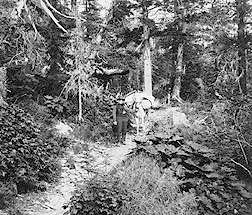
| Prospector on the TransAlaska military Pack trail through keystone
Canyon, Miles Brother photo, 1903, Valdez Museum Archives. This section
of the trail remains much the same today as when first built by soldiers
and destitute prospectors hired by the Army in the summer of 1899. |
|
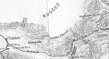
1. West Keystone Canyon Pack Train Section:
The trail begins from the old Richardson Highway loop just west of Keystone
Canyon on the north side of the highway. Red flags mark the trailhead.
This section leads through the old growth Sitka transitional rainforest
which is good habitat for black and brown bears as well as some moose and
Sitka deer. The original log culverts and retaining wall rockwork can be
seen along the trail. After a steep slide (imagine what this was like for
women riding sidesaddle in skirts), the pack train trail encounters the
wagon road which was constructed on top of the original trail. If you turn
right (west), you will end up at the Bridal Veil Falls trailhead. Left
leads to Snowslide Gulch. (Distance from West Keystone Canyon to Bridal
Veil Falls: approx. 2-1/2 miles). |
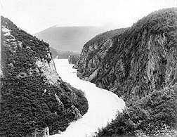
| 2. "Goat Trail Section": Park at Bridal
Veil Falls. There is a dirt path next to the highway which leads to the
old wagon road locally known as the "Goat Trail." The Valdez Boy Scouts
maintain this section of the trail. About 100 yards up the trail, the pack
train trail enters on the left. The best views along the pack train trail
are heading west. The Goat Trail passes through a section of steep,
alder covered hillsides. Note the cuts the early trail builders made in
the cliffs to create the trailbed. If you look carefully, you will see
remains of the old telegraph line (WAMCATS), the first telegraph system
to connect Alaska to the rest of the world. The Goat Trail leads to Snowslide
Gulch (3.), a distance of about 2-1/2 miles. Because the stream is
often impassable, hikers should expect to turn around at this point. Funding
has been obtained to install a bridge in 1999. There are some spectacular
vistas of Keystone Canyon's waterfalls, rafters running the Lowe River,
and the Dutch Flats area. Corporal Heiden named the area after a group
of Dutch prospectors who helped the Army scouts across Bear and Sheep Creeks
and fed them. |
|
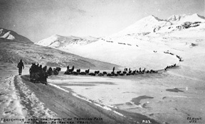 |
| For many years, the Valdez to Fairbanks Trail was the major transportation
route to interior Alaska. Most freighting was done in the winter
when travel was easier. Today, this is a major winter recreation
area. PS Hunt photo, 1903, Valdez Museum Archives. |
|
4. Dutch Flats Wagon Road Section:
Walk along the Bear Creek dike towards the Bear Creek Bridge, which was
built in 1943 by the Army as part of the WW II effort. Near the hillside
a trail leads off to the right and connects to the old wagon road
and early Richardson Highway. Warning: The surface of Bear Creek Bridge
is rotten with some holes large enough for children to fall through. Parents
are encouraged to keep watch on their children. If you follow the old road
to the east (right), you will not come near the bridge. This is a very
pleasant walk, nearly level, through a Sitka spruce forest. Take the trail
exit to the Richardson Highway at the Mile 18.5 Pullout (5).(Distance from
Bear Creek to Mile 18.5, approx. 2 miles). |
| Guided nature & historical hikes: |
Matt Kinney, 907-835-4817 -
Website - |
| Local Transportation to Trail: |
Avis Rent-A-Car, 835-4774
Valdez U-Drive, 835-4402 |
| Lodging: |
Valdez Village Inn, 835-4445;
Lake House B&B, 835-4445
Thompson Pass Mt. Chalet, 835-4817 -Website- |
| Outfitting: |
The Prospector, 835-3858
Beaver Sports, 835-4727 |
| Prince William Sound Books |
Valdez Gold Rush Trails 1898-99 -Website- |
| Valdez Convention & Visitor's Bureau |
835-2984; 800-770-5954; - Website
- |
| Valdez Museum |
835-2764 - Website
- |